Shading Objects
SolarFarmer is built on a full 3D model and shading objects can be added to this model in addition to the terrain data. All these may cause shading effects on the PV modules.
There are two ways to add shading objects:
Add Pre-defined 3D Objects
3D objects prepared in other software packages (such as Sketchup) that
have been saved in COLLADA (Collaborative Design Activity) *.dae format
can be imported into the SolarFarmer workbook and positioned in the
site. This is particularly suited to complex objects or objects that you
want repeated across the site area.
Import the 3D object model into the workbook (click the 'Import 3D model' button to select it).
a. The object will be shown in the 3D Model Shading Object Library in the top-left panel.
b. You may add several objects to the library.
Select the object in the library that you wish to add an instance of to the map.
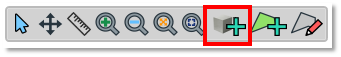
Select the 'Located 3D Object' tool in the map's toolbar (grey cube with green '+' symbol highlighted in red below)
Click on the map to add an instance of that 3D object at the location you click
a. The map tool reverts to the 'Select' tool -- click and drag the object to exactly where you want it.
Switch the map to 3D mode (the '3D button in the top-middle of the map) to view the objects in 3D.
Tip
Hold down the CTRL keyboard key whilst adding 3D objects to maintain the adding object functionality so you can quickly add multiple objects.
Define Simple Boundary-Based Shading Objects
If you don't have access to a 3D modelling package, or you just want to create a quick 3D volume to approximate a forest, hedge or building, you can add a shading region.
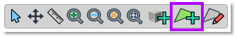
Click on the 'Shading region' button in the map toolbar (green polygon with '+' symbol highlighted in purple below).
Click on the map to add points to form a polygon. Finish the polygon by clicking on the first point you clicked.
A new shading region object is added to the map and also to the table in the 'Shading Region Objects' table in the bottom-left panel.
Set the height of the shading region (height above the terrain) and the type:
a. 'Follows terrain' means that the height of the volume will be the same above each point. Useful for forests or hedges whose height you want to follow the terrain.
b. 'Flat top' means that the 3D volume will have a horizontal top face. Useful for modelling simple flat-topped buildings.
Again, switch the map to 3D mode to see the 3D volume.
Tip
You can also double-click on the last point to quickly finish a polygon.
Tip
You can adjust the height of the shading regions whilst in 3D mode to fine-tune the height of the shading regions.