Horizon Line
Horizon data is used to tell the energy yield calculation when direct sunlight is/isn't available to the site, depending on the position of the sun.
You can import an existing horizon file (from Meteonorm or PVsyst) if you already have one for your site.
Or you can use the terrain data that you have downloaded to generate a horizon for your site. Click on Generate... to show the Generate Horizon tool.
Generating a Horizon
To generate horizon data for your site click on the Generate... button to show the Generate Horizon tool.
The algorithm uses a viewpoint slightly above the ground and renders terrain in all 360° directions from the near radius to the far radius away from the view location. The terrain inside the near radius is used in the near-shading model (in the energy yield calculation) and thus isn't used for the horizon.
A far radius of around 30km is generally sufficient. The dialog will prompt you if you have downloaded insufficient terrain. Either reduce the far radius so that it covers the available terrain or press the button to auto-download the terrain required.
Once generated, the chart shows you the path of the sun (azimuth along the x-axis, elevation up the y-axis) in summer, winter and in between. Then overlays the horizon over that so you can see when the sun will be obscured by the horizon. (Note SolarFarmer uses angle clockwise from true north when presenting azimuth angles throughout the application, unlike some other PV design packages).
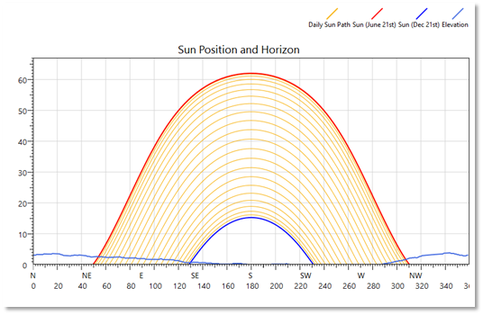
Example of sun positions and horizon