Site Layouts
A site layout defines the instances of all the library objects you have previously added, laid out geographically over the site area. Each workbook has at least one site layout but you may define several. When the energy yield calculation is run you must choose only one of the site layouts.
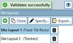
The site layouts in a workbook are accessed (and changed) using the 'Site layouts' panel that appears in the bottom left corner of the 'Lay out plant -> Design layout' task:
Adding a New Site Layout
You can add a new site layout by pressing the 'Add' button in the Site Layouts panel. When you add a new site layout, or the first time you use the default site layout in the workbook, you must choose whether to work with fixed-tilt racks or single-axis trackers. You cannot mix fixed-tilt racks and trackers in the same site layout.
Cloning an Existing Site Layout
If you wish to make an exact copy of an existing site layout (you may then want to slightly modify this copy) select the site layout you wish to clone, then press the 'Clone' button in the Site Layouts panel. A new site layout will be created that will be an exact copy of the selected site layout.
Exporting a Site Layout
Press the 'Export...' button to show the 'Export Site Layout' dialog:
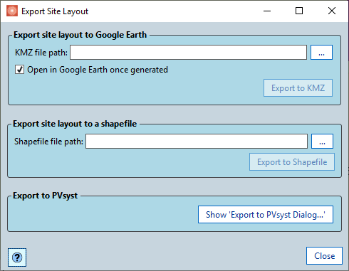
There are 3 formats you can export the 3D racks or trackers:
Export to Google Earth
You can export the 3D racks or trackers to a Google Earth *.kmz file for viewing in Google Earth. Once you have chosen a file to export to you can add an optional offset that is added to the locations of the racks/trackers to help compensate for the fact that the background imagery in Google Earth isn't always accurately placed.
Note
You can also export to Google Earth using the scripting function:
Toolbox.Export.ExportSiteLayoutToGoogleEarth(string fullFilePath,
SiteLayout siteLayoutToExport, bool openFileInGoogleEarthAfterExport,
[double eastOffset], [double northOffset]);
Exporting to a Shapefile
You can export the 3D racks or trackers to a shapefile (*.shp). This can then be imported into other software packages such as AutoCAD or GIS software.
One shapefile is exported for the site layout, which contains an area feature for each rack or tracker. The points of each feature contain X, Y and Z coordinates (in the workbook projection). An ELEVATION attribute is also added per feature - this is the minimum Z coordinate for the feature.
Note
You can also export to shapefile using the scripting function:
Toolbox.Export.ExportSiteLayoutToShapefile(
    string fullFilePath, SiteLayout siteLayoutToExport);
Exporting to PVsyst
You can the site layout to a PVsyst project. See Export to PVsyst for more information on this.
Specify Site Layout Tool
You can lay out sites using parameters (rather than draw them out by hand) using the specify site functionality. Access this using the 'Specify...' button in the Site Layouts panel. See Specify Site Layout Tool for more details on how to use this.